All traffic signs and their meanings. Groups of traffic signs
All signs traffic are divided into eight groups, each of which serves to convey certain information to the driver. This article discusses in detail the features of each type of plates, as well as their main functions.
Groups of traffic signs
All used in the territory Russian Federation, signs are divided into the following groups:
- warning signs;
- priority signs;
- prohibition signs;
- prescriptive signs;
- signs special instructions;
- information signs;
- service marks;
- signs additional information.
Each group of road signs has its own shape and color tone. In addition, all plates have a digital identifier. The first digit is the group, the second is the number within the group, and the third is the species.
Each group serves to convey to the driver any information or a ban on movement.
Classification of road signs- warning signs
Distinctive features of such signs are triangular-shaped plates, a white background on which symbols are applied in black paint, and a red edging.
A warning sign, according to the rules, is placed 50 or 100 meters before the danger zone in a city or countryside, and for 150-300 meters on the roads outside the settlements. If it is not possible to install a sign at the prescribed distance, the distance to the dangerous area in meters is indicated at the bottom of the plate. These road signs are usually triangular shape, so it is almost impossible to confuse them.
Warning signs are installed rectangular and cross-shaped. Their installation is determined by separate norms and rules. So, signs 1.1, 1.2, 1.9, 1.10 and some others are placed exclusively outside cities and villages. The minimum information distance regarding the danger zone is 50 meters. Plates 1.23 and 1.25 are installed directly on the emergency site.
Warning signs 1.7, 1.17, 1.22 indicate that there is no roundabout or pedestrian crossing further along the path. They are additionally accompanied by plates from other groups.
What road signs are from the group of priority characters

Priority plates indicate a certain one, which is considered the main one in relation to other movement trajectories. Usually you see such signs at intersections and other similar areas with difficult traffic. Regulation signs may also be placed on narrow roads.
The sign "Movement without stopping is prohibited" is most often found near railways and barriers to prevent accidents with trains.
In some cases, on the road you can see a regulatory sign and a traffic light, or a sign and a traffic controller. In this case, priority is given to traffic signals or a traffic controller / traffic police officer. Be careful under these circumstances. Only if the traffic light is turned off, you need to focus on the sign.
Types of traffic signs- prohibition signs

As could be understood from the name of the group, prohibition signs inform the driver about the prohibition of movement.
In turn, such signs are divided into prohibitory and restrictive. In the first case, passage is strictly prohibited, and in the second, it is allowed to continue driving, but with maximum caution.
Prohibition signs are always round, with a white background, on which a certain pattern is applied in black paint. The exception is four plates with a blue background. In addition, there are four black and white signs that allow previously prohibited traffic.
The signs of this group are the most difficult to learn: for prohibition and limiting signs, some exceptions have been introduced that apply to specific modes of transport. In addition, it is difficult to navigate in the territory of action of a sign.
- The first exception applies to drivers who have turned on special signals and red-blue lights and are performing some official mission. In this case, any prohibition sign can be ignored.
- Signs 16, 3.17.1, 3.17.2, 3.17.3, 3.20, 3.24 in without fail taken into account by all motorists.
- The presence of plates 1, 3.2, 3.3, 3.18.1, 3.18.2, 3.19, 3.27 does not apply to minibuses.
- Signs 3.2, 3.3, 3.4, 3.5, 3.6, 3.7, 3.8, 3.28, 3.29, 3.30 may ignore post cars.
- Plates numbered 3.2, 3.3, 3.28, 3.29, 3.30 may be neglected by drivers carrying disabled people of the first and second groups.
- Ignore signs 3.2, 3.3, 3.5, 3.6, 3.7, 3.8 have the right to employees of factories and enterprises located in the area of the sign, as well as drivers carrying passengers who live in this area.
- Taxi drivers with an activated meter can ignore signs 3.28, 3.29 and 3.30.
- Plate 3.26 allows you to horn to prevent an accident.
- And the last exception - sign 3.20 allows you to go around a car that cannot reach a speed of more than 30 kilometers per hour, as well as a motorcycle, bicycle or wagon.
It is often difficult to figure out where the action of a particular sign ends. To do this, learn four rules.
- The action of specific signs ceases before the first intersection.
- If a certain plate is installed in an urban or rural area, then its validity is terminated outside the territory of the settlement. Outside the city or village there is always a crossed out sign with the name of the settlement.
- The coverage area may be indicated on the sign itself.
- Sign 3.31 cancels all previous ones.
Types of road signs- prescriptive signs

Similar signs apply to absolutely everyone. They can indicate the direction in which it is allowed to continue moving, the maximum or the route of passage for special vehicles. In addition, mandatory signs may allow pedestrians or cyclists to move.
Almost all such signs are round, with a blue background and white pictograms.
Features of road signs
- Tablets 4.1.1 - 4.1.6 indicate the trajectory of traffic at a particular intersection.
- On the signs 4.1.3, 4.1.5 and 4.1.6 an arrow is drawn, which allows movement exclusively to the left. In addition, in this place you can turn around.
- Signs 4.1.1 - 4.1.6 can be ignored by drivers of minibuses and buses.
8 groups of road signs
Four groups of road signs were considered above. It remains to disassemble the same number of types, namely: signs of special requirements, information signs, service plates and signs of additional information.
Categories of road signs- signs of special regulations

On some roads it is impossible to establish a generally accepted traffic norm. It is in such situations that special prescription signs are used that inform drivers about special driving modes.
- Signs 5.23.1, 5.23.2, 5.24.1, 5.24.2 are placed on the territory for which the traffic rules are relevant for settlements.
- Tablets 5.25 and 5.26 inform about the invalidity of the rules for urban or rural areas.
- Signs 5.27, 5.29, 5.31, 5.33 apply to a specific area without exception, whether it is an intersection or any other road with non-standard traffic.
Group of information signs
Similar plates were created for drivers about different settlements, as well as the location of certain cities and villages.
These signs are always rectangular, and the main color may vary, depending on the subgroup. For example, a green background is used for highway features. A white background is used to indicate objects within a certain point, yellow - if roads are being repaired. Blue is used to indicate routes outside the city.
Categories of traffic signs- signs of additional information

Additional signs serve for more detailed information. They are complementary to the main characters. Therefore, they cannot be used on their own. According to the rules, no more than three plates can be attached to one sign.
If the additional sign contradicts the main sign, the driver must follow the instructions of the temporary plate. Additional signs are mainly installed during renovation work.
Categories of road signs- service marks
As you might have guessed, such signs indicate various points, for example, car repairs or refueling.
They are hung in the city near the object itself, and in the countryside, or outside the city, in advance - from 400 meters to 80 kilometers.
Rounding of the road of small radius or with limited visibility: 1.11.1 - to the right, 1.11.2 - to the left.
Road section with dangerous turns: 1.12.1 - with the first turn to the right, 1.12.2 - with the first turn to the left.
Narrowing on both sides - 1.20.1, on the right - 1.20.2, on the left - 1.20.3.
Adjacency on the right - 2.3.2, 2.3.4, 2.3.6, on the left - 2.3.3, 2.3.5, 2.3.7.
It is forbidden to enter a narrow section of the road, if this may impede oncoming traffic. The driver must give way to oncoming vehicles located on a narrow section or the opposite entrance to it.
A narrow stretch of road where the driver has priority over oncoming vehicles.
3. Prohibition signs.
Prohibition signs introduce or cancel certain traffic restrictions.
The movement of trucks and vehicles with a maximum authorized mass of more than 3.5 tons (if the mass is not indicated on the sign) or with a maximum authorized mass of more than indicated on the sign, as well as tractors and self-propelled machines, is prohibited.
3.5 "Motorcycles prohibited".
3.6 "Movement of tractors is prohibited." The movement of tractors and self-propelled machines is prohibited.
3.7 "Moving with a trailer is prohibited."
The movement of trucks and tractors with trailers of any type, as well as the towing of mechanical vehicles, is prohibited.
3.8 "The movement of horse-drawn carts is prohibited."
The movement of horse-drawn carts (sleighs), riding and pack animals, as well as the driving of livestock is prohibited.
3.9 "Biking is prohibited." Bicycles and mopeds are prohibited.
3.10 "Pedestrian traffic is prohibited."
3.11 "Weight limitation".
It is forbidden to move vehicles, including vehicles, the total actual mass of which is more than indicated on the sign.
3.12. "Mass limit per vehicle axle".
The movement of vehicles whose actual mass on any axle exceeds that indicated on the sign is prohibited.
3.13 "Height limitation".
The movement of vehicles whose overall height (with or without cargo) is more than indicated on the sign is prohibited.
3.14 "Width limitation". The movement of vehicles whose overall width (with or without cargo) is greater than that indicated on the sign is prohibited.
3.15 "Length limitation".
The movement of vehicles (vehicle combinations) whose overall length (with or without cargo) is greater than that indicated on the sign is prohibited.
3.16 "Minimum distance limitation".
The movement of vehicles with a distance between them less than indicated on the sign is prohibited.
3.17.1 "Customs". It is forbidden to travel without stopping at the customs (checkpoint).
3.17.2 "Danger".
Forbidden further movement all vehicles without exception in connection with a traffic accident, accident, fire or other danger.
3.17.3 "Control". Passing through checkpoints without stopping is prohibited.
3.18.1 "No right turn".
3.18.2 "No left turn".
3.19 "No U-turn".
3.20 "Overtaking prohibited".
It is forbidden to overtake all vehicles, except for slow-moving vehicles, horse-drawn carts, mopeds and two-wheeled motorcycles without a sidecar.
3.21 "End of no-overtaking zone".
3.22 "Overtaking by trucks is prohibited."
Trucks with a maximum authorized mass of more than 3.5 tons are prohibited from overtaking all vehicles.
3.23 "End of no overtaking zone for trucks".
3.24 "Maximum speed limit".
It is forbidden to drive at a speed (km/h) exceeding that indicated on the sign.
3.25 "End of the maximum speed limit zone".
3.26 "Sounding is prohibited."
It is forbidden to use sound signals, except when the signal is given to prevent a traffic accident.
3.27 "Stopping prohibited". Stopping and parking of vehicles is prohibited.
3.28 "Parking prohibited". Parking of vehicles is prohibited.
3.29 "Parking is prohibited on odd days of the month."
3.30 "Parking is prohibited on even days of the month."
At simultaneous application signs 3.29 and 3.30 on opposite sides of the carriageway, parking is allowed on both sides of the carriageway from 19:00 to 21:00 (changing time).
3.31 "End of the zone of all restrictions".
Designation of the end of the coverage area at the same time several characters from the following: 3.16, 3.20, 3.22, 3.24, 3.26 - 3.30.
3.32 "The movement of vehicles with dangerous goods is prohibited."
The movement of vehicles equipped with identification signs (information plates) "Dangerous goods" is prohibited.
3.33 "The movement of vehicles with explosive and flammable goods is prohibited."
The movement of vehicles transporting explosive substances and products, as well as other dangerous goods subject to marking as flammable, is prohibited, except for the cases of transportation of these dangerous substances and products in a limited amount, determined in the manner established special rules transportation.
prohibition signs
Signs 3.2 - 3.9, 3.32 and 3.33 prohibit the movement of the respective types of vehicles in both directions.
Signs do not apply:
3.1 - 3.3, 3.18.1, 3.18.2, 3.19, 3.27 - on route vehicles, if the route is laid out in this way and vehicles with a blue or blue-red flashing beacon;
3.2 - 3.8 - for vehicles of federal postal organizations that have a white diagonal stripe on a blue background on the side surface, and vehicles that serve enterprises located in a designated area, as well as serve citizens or belong to citizens living or working in a designated area . In these cases, vehicles must enter and exit the designated area at the intersection closest to their destination;
3.28 - 3.30 - for vehicles of federal postal organizations that have a white diagonal stripe on a blue background on the side surface, as well as for taxis with a taximeter turned on;
3.2, 3.3, 3.28 - 3.30 - for vehicles driven by disabled people of groups I and II or carrying such disabled people.
The effect of signs 3.18.1, 3.18.2 applies to the intersection of carriageways in front of which the sign is installed.
The zone of action of signs 3.16, 3.20, 3.22, 3.24, 3.26 - 3.30 extends from the place where the sign is installed to the nearest intersection behind it, and in populated areas in the absence of an intersection - to the end of the populated area. The action of the signs is not interrupted at the places of exit from the territories adjacent to the road and at the places of intersection (adjacency) with field, forest and other secondary roads, in front of which the corresponding signs are not installed.
The effect of the sign 3.24, installed in front of the settlement, indicated by the sign 5.23.1 or 5.23.2, extends to this sign.
The area of effect of signs can be reduced:
for signs 3.16 and 3.26 using plate 8.2.1;
for signs 3.20, 3.22, 3.24 by installing signs 3.21, 3.23, 3.25 at the end of their coverage zone, respectively, or by using plate 8.2.1. Sign 3.24 coverage area can be reduced by setting sign 3.24 with a different maximum speed;
for signs 3.27 - 3.30 by installing repeated signs 3.27 - 3.30 with plate 8.2.3 at the end of their coverage area or using plate 8.2.2. Sign 3.27 can be used in conjunction with marking 1.4, and sign 3.28 - with marking 1.10, while the area of operation of signs is determined by the length of the marking line.
Signs 3.10, 3.27 - 3.30 are valid only on the side of the road on which they are installed.
4. Mandatory signs.
4.1.1 "Going straight ahead".
4.1.2 "Move to the right".
4.1.3 "Moving to the left".
4.1.4 "Going straight or to the right".
4.1.5 "Going straight or left".
4.1.6 "Move to the right or to the left".
Movement is allowed only in the directions indicated by arrows on the signs. Signs that allow a left turn also allow a U-turn (signs 4.1.1 - 4.1.6 can be used with an arrow configuration corresponding to the required directions of movement at a particular intersection).
Signs 4.1.1 - 4.1.6 do not apply to route vehicles. The effect of signs 4.1.1 - 4.1.6 applies to the intersection of carriageways, in front of which a sign is installed. The effect of the sign 4.1.1, installed at the beginning of the road section, extends to the nearest intersection. The sign does not prohibit right turns into courtyards and other areas adjacent to the road.
4.2.1 "Obstacle avoidance on the right".
4.2.2 "Obstacle avoidance on the left". Detour is allowed only from the side indicated by the arrow.
4.2.3 "Obstacle avoidance on the right or left". Detour is allowed from any direction.
4.3 "Roundabout". From November 8, 2017, the driver of a vehicle entering such an intersection must give way to vehicles moving at this intersection. If priority signs or a traffic light are installed at a roundabout, then the movement of vehicles on it is carried out in accordance with their requirements.
4.4.1 "Bicycle path".
Only bicycles and mopeds are allowed. Pedestrians can also move along the cycle path (in the absence of a sidewalk or footpath).
4.4.2 "End bike path". End of the cycle path marked with sign 4.4.1.
4.5.1 "Pedestrian path". Only pedestrians are allowed.
4.5.2 "Pedestrian and cycle path with combined traffic." Bicycle path with combined traffic.
4.5.3 "End of combined pedestrian and cycle path". The end of the cycle path with combined traffic.
4.5.4 - 4.5.5 "Pedestrian and cycle path with traffic separation". Bicycle path divided into bicycle and pedestrian sides of the path, allocated structurally and (or) marked with horizontal markings 1.2, 1.23.2 and 1.23.3 or otherwise.
4.5.6 - 4.5.7 "End of pedestrian and cycle path with traffic separation". End of cycle path with traffic separation.
4.6 "Minimum speed limit". Driving is allowed only at the specified or higher speed (km/h).
4.7 "End of the minimum speed limit zone".
The movement of vehicles equipped with identification signs (information tables) "Dangerous goods" is allowed only in the direction indicated on the sign: 4.8.1 - straight ahead, 4.8.2 - to the right, 4.8.3 - to the left.
5. Signs of special prescriptions.
Signs of special regulations introduce or cancel certain modes of movement.
5.1 "Motorway".
The road on which the requirements of the Rules of the Road of the Russian Federation, which establish the procedure for driving on motorways, apply.
5.2 "End of motorway".
5.3 "Road for cars".
A road reserved for the movement of cars, buses and motorcycles only.
5.4 "End of the road for cars".
5.5 "One-way road".
A road or carriageway on which vehicular traffic across its entire width is in the same direction.
5.6 "End of one-way road".
5.7.1, 5.7.2 "Entering a one-way road". Drive onto a one-way road or carriageway.
5.8 "Reverse movement".
The beginning of a section of road where one or more lanes can change direction.
5.9 "End of reverse movement".
5.10 "Entering the road with reverse traffic."
5.11 "Road with a strip for route vehicles". The road along which the movement of fixed-route vehicles, cyclists and vehicles used as a passenger taxi is carried out along a specially allocated lane towards the general flow of vehicles.
5.12 "The end of the road with a strip for route vehicles."
5.13.1, 5.13.2 "Exit to the road with a lane for route vehicles".
5.13.3, 5.13.4 "Entering a road with a lane for cyclists". Departure to the road with a lane for cyclists, whose movement is carried out along a specially allocated lane towards the general flow.
5.14 "Lane for route vehicles". A lane intended for the movement of only route vehicles, cyclists and vehicles used as a passenger taxi, moving along with the general flow of vehicles.
5.14.1 "Lane end for route vehicles".
5.14.2 "Lane for cyclists" - a lane of the carriageway intended for movement on bicycles and mopeds, separated from the rest of the carriageway by horizontal markings and marked with the sign 5.14.2.
5.14.3 "End of lane for cyclists". Sign 5.14.3 applies to the lane above which it is located. The effect of signs installed to the right of the road applies to the right lane.
 5.15.1 "Directions of traffic on lanes".
The number of lanes and permitted directions of movement for each of them.
 5.15.2 "Directions of movement along the lane".
Permitted lane directions.
Signs 5.15.1 and 5.15.2, allowing a left turn from the leftmost lane, also allow a U-turn from this lane.
Signs 5.15.1 and 5.15.2 do not apply to route vehicles. The effect of signs 5.15.1 and 5.15.2, installed in front of the intersection, applies to the entire intersection, unless other signs 5.15.1 and 5.15.2, installed on it, give other indications.
 5.15.3 "Beginning of lane".
Beginning of an additional lane on an uphill or deceleration lane. If the sign placed in front of the additional lane shows the sign (signs) 4.6 "Minimum speed limit", then the driver of the vehicle, who cannot continue driving along the main lane at the specified or higher speed, must change lanes to the right of him.
 5.15.4 "Beginning of lane".
The beginning of the section of the middle lane of a three-lane road intended for traffic in this direction. If the sign 5.15.4 shows a sign prohibiting the movement of any vehicles, then the movement of these vehicles in the corresponding lane is prohibited.
5.15.5 "End of lane". End of an additional lane on the rise or acceleration lane.
5.15.6 "End of lane".
The end of a section of the middle lane on a three-lane road intended for traffic in this direction.
 5.15.7 "Direction of traffic on lanes".
If the sign 5.15.7 shows a sign prohibiting the movement of any vehicles, then the movement of these vehicles in the corresponding lane is prohibited.
Signs 5.15.7 with the appropriate number of arrows may be used on roads with four or more lanes.
 5.15.8 "Number of lanes".
Indicates the number of lanes and the lane modes. The driver is obliged to comply with the requirements of the signs on the arrows.
5.16 "Bus and (or) trolleybus stop place".
5.17 "Tram stop place".
5.18 "Place of parking of passenger taxis".
5.19.1, 5.19.2 "Pedestrian crossing".
If there are no markings 1.14.1 or 1.14.2 at the crossing, sign 5.19.1 is installed to the right of the road at the near border of the crossing relative to approaching vehicles, and sign 5.19.2 - to the left of the road at the far border of the crossing.
5.20 "Artificial unevenness".
Indicates the boundaries of artificial unevenness. The sign is installed on the nearest border of artificial unevenness relative to approaching vehicles.
5.21 "Residential area".
The territory on which the requirements of the Rules of the Road of the Russian Federation are in force, establishing the procedure for driving in a residential area.
5.22 "End of residential area".
![]()
![]() 5.23.1, 5.23.2 "Beginning of settlement".
5.23.1, 5.23.2 "Beginning of settlement".
The beginning of a settlement in which the requirements of the Rules of the Road of the Russian Federation are in force, establishing the order of movement in settlements. ![]()
![]() 5.24.1, 5.24.2 "End of settlement".
5.24.1, 5.24.2 "End of settlement".
The place from which the requirements of the Rules of the Road of the Russian Federation, which establish the procedure for driving in populated areas, become invalid on this road.
![]() 5.25 "The beginning of the settlement."
5.25 "The beginning of the settlement."
The beginning of a settlement where the requirements of the Rules of the Road of the Russian Federation, which establish the procedure for driving in settlements, do not apply on this road.
![]() 5.26 "End of settlement".
5.26 "End of settlement".
The end of a built-up area where the requirements of the Rules of the Road of the Russian Federation, which establish the procedure for driving in built-up areas, do not apply on this road.
5.27 "Parking restriction zone".
The place from which the territory (section of the road) begins, where parking is prohibited.
5.28 "End of restricted parking zone".
5.29 "Regulated parking zone".
The place from which the territory (section of the road) begins, where parking is allowed and regulated using signs and markings.
5.30 "End of regulated parking zone".
5.31 "Zone with a maximum speed limit".
The place from which the territory (section of the road) begins, where it is limited maximum speed movement.
5.32 "End of zone with maximum speed limit".
5.33 "Pedestrian zone".
The place from which the territory (section of the road) begins, on which only pedestrian traffic is allowed.
5.34 "End of the pedestrian zone".
5.35 "Zone with a restriction of the environmental class of motor vehicles."
Indicates the place from which the territory (section of the road) begins, where the movement of motor vehicles is prohibited: the ecological class of which, specified in registration documents for these vehicles below the environmental class indicated on the sign; the environmental class of which is not indicated in the registration documents for these vehicles.
5.36 "Zone with restriction of the environmental class of trucks."
Indicates the place from which the territory (section of the road) begins, where the movement of trucks, tractors and self-propelled vehicles is prohibited: the environmental class of which, indicated in the registration documents for these vehicles, is lower than the environmental class indicated on the sign; the environmental class of which is not indicated in the registration documents for these vehicles.
5.37 "End of the zone with the restriction of the environmental class of motor vehicles."
5.38 "End of the zone with the restriction of the environmental class of trucks."
6. Information signs.
Information signs inform about the location of settlements and other objects, as well as about the established or recommended driving modes.
6.1 "General maximum speed limits".
General speed limits established by the Rules of the Road of the Russian Federation.
The speed at which traffic is recommended on this section of the road. The zone of action of the sign extends to the nearest intersection, and when sign 6.2 is used in conjunction with a warning sign, it is determined by the length of the dangerous section.
6.3.1 "Place to turn around". Left turns are prohibited.
6.3.2 "Turn area". The length of the turn zone. Left turns are prohibited.
6.4 "Parking place".
6.5 "Emergency stop lane". Emergency stop lane on a steep descent.
6.6 "Underground pedestrian crossing".
6.7 "Elevated pedestrian crossing".
6.8.1 - 6.8.3 "Dead end". A road with no through passage.
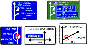 6.9.1 "Advance direction indicator"
 6.9.2 "Advance direction indicator".
Driving directions to the settlements and other objects indicated on the sign. Signs may bear images of the sign 6.14.1  , symbols of the highway, airport and other pictograms. On sign 6.9.1, images of other signs informing about the peculiarities of traffic may be applied. The lower part of the sign 6.9.1 indicates the distance from the location of the sign to the intersection or the beginning of the braking lane.
Sign 6.9.1 is also used to indicate the detour of road sections on which one of the prohibition signs 3.11 - 3.15 is installed.
6.9.3 "Traffic plan".
The route of movement when certain maneuvers are prohibited at the intersection or permitted directions of movement at a complex intersection.
 6.10.1 "Direction indicator"
 6.10.2 "Direction indicator".
Driving directions to waypoints. The signs may indicate the distance (km) to the objects marked on them, symbols of the highway, airport and other pictograms.
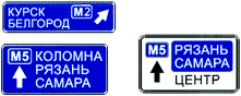
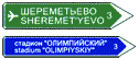
6.11 "Object name".
The name of an object other than a settlement (river, lake, pass, landmark, etc.).
 6.12 "Distance indicator".
Distance (km) to settlements located on the route.
6.13 "Kilometer sign". Distance (km) to the beginning or end of the road.
 6.14.1, 6.14.2 "Route number".
6.14.1 - number assigned to the road (route); 6.14.2 - number and direction of the road (route).
6.16 "Stop line".
Place where vehicles stop at a prohibitory traffic light signal (traffic controller).
6.17 "Detour scheme". Detour route for a section of road temporarily closed to traffic.
Detour direction of a section of road temporarily closed to traffic.
6.19.1, 6.19.2 "Advance sign for changing lanes".
Direction to bypass a section of the carriageway closed to traffic on a median road or direction of traffic to return to the right carriageway.
6.20.1, 6.20.2 "Emergency exit". Indicates the location in the tunnel where the emergency exit is located.
![]()
![]() 6.21.1, 6.21.2 "Direction of movement to the emergency exit". Indicates the direction to the emergency exit and the distance to it.
6.21.1, 6.21.2 "Direction of movement to the emergency exit". Indicates the direction to the emergency exit and the distance to it.
On signs 6.9.1, 6.9.2, 6.10.1 and 6.10.2, installed outside the settlement, a green or blue background means that the movement to the indicated settlement or object will be carried out respectively by motorway or other road. On the signs 6.9.1, 6.9.2, 6.10.1 and 6.10.2, installed in the settlement, inserts with a background of green or of blue color mean that the movement to the specified settlement or object after leaving this settlement will be carried out respectively on the motorway or other road; the white background of the sign means that specified object located in this locality.
7. Service marks.
Service signs inform about the location of the respective objects.
7.1 "Point of medical aid".
Complete table of traffic signs with explanations for 2018. Detailed comments on road signs SDA 2018.
warning signs


Warning road signs of this group inform motorists about a dangerous section of the road that requires action from the driver. In most cases, warning signs are a triangle with a red border.
Explanation of Warning Signs 2018
1.1 Railway crossing with barrier
They are installed in a populated area 50-100 m away, outside populated areas 150-300 m before the start of the hazardous area. Approaching a railway crossing equipped with a barrier. The driver must slow down and assess the situation. This sign is duplicated only outside the settlement, the second sign is installed at a distance of at least 50 m before the beginning of the dangerous section.
1.2 Railway crossing without barrier
They are installed in a populated area 50-100 m away, outside populated areas 150-300 m before the start of the hazardous area. Approaching a railway crossing that is not equipped with a barrier. The driver must slow down and assess the situation. This sign is duplicated only outside the settlement, the second sign is installed at a distance of at least 50 m before the beginning of the dangerous section.
1.3.1 Single track railway
Are established directly before railway crossings without a barrier. Approaching a single-track railway crossing that is not equipped with a barrier. Drivers are warned about the presence of a railway crossing with one track that is not equipped with a barrier. The driver must slow down and assess the situation.
1.3.2 Multitrack railway
Are established directly before railway crossings without a barrier. Approaching a multi-track railway crossing that is not equipped with a barrier. Drivers are warned about the presence of a railway crossing with several tracks that is not equipped with a barrier. The driver must slow down and assess the situation.
1.4.1 - 1.4.6 Approaching a level crossing
Additional warning about approaching a railway crossing outside built-up areas. This sign can be installed simultaneously on the right and left side of the road (the sloping red stripe is directed towards the carriageway). Signs are installed:
- 1.4.1, 1.4.4 - for 150 - 300 meters
- 1.4.2, 1.4.5 - for 100 - 200 meters
- 1.4.3, 1.4.6 - for 50 - 100 meters
1.5 Crossing with the tram line
They are installed in a populated area 50-100 m away, outside populated areas 150-300 m before the start of the hazardous area. Warns about approaching the intersection with tram tracks outside the intersection or in front of the intersection with limited visibility of the tram tracks (less than 50 m). When approaching such an intersection, the driver must be especially careful, since in most cases the tram has preemptive right to traffic, that is, the driver must give way to the tram. The driver must slow down and assess the situation.
1.6 Crossing equivalent roads
They are installed in a populated area 50-100 m away, outside populated areas 150-300 m before the start of the hazardous area. Can be equipped with a pedestrian crossing. You must give way to any vehicles approaching from the right and to pedestrians. The driver must slow down and assess the situation.
1.7 Roundabout
They are installed in a populated area 50-100 m away, outside populated areas 150-300 m before the start of the hazardous area. Warns of approaching a roundabout. The movement in the ring goes counterclockwise. The driver is advised to slow down and assess the situation.
1.8 Traffic light regulation
They are installed in a populated area 50-100 m away, outside populated areas 150-300 m before the start of the hazardous area. Warns of an intersection, pedestrian crossing, or other section of road where traffic is regulated by a traffic light. The driver is advised to slow down and assess the situation.
1.9 Drawbridge
They are installed in a populated area 50-100 m away, outside populated areas 150-300 m before the start of the hazardous area. Drawbridge or ferry crossing. When entering the ferry, you must follow the instructions of the ferry duty officer, passing vehicles leaving the ferry. The driver is advised to slow down and assess the situation. This sign is duplicated only outside the settlement, the second sign is installed at a distance of at least 50 m before the beginning of the dangerous section.
1.10 Departure to the embankment
They are installed in a populated area 50-100 m away, outside populated areas 150-300 m before the start of the hazardous area. Departure to the embankment or shore. They warn drivers about the exit to the embankment, the bank of the river, lake, where there is a danger of the vehicle exiting into the water. The driver is advised to slow down and assess the situation. This sign is duplicated only outside the settlement, the second sign is installed at a distance of at least 50 m before the beginning of the dangerous section.
1.11.1, 1.11.2 Dangerous turn
They are installed in a populated area 50-100 m away, outside populated areas 150-300 m before the start of the hazardous area. Rounding of the road of small radius or with limited visibility to the right. The driver must remember that in such areas such maneuvers as overtaking, turning and reversing are prohibited. The driver must slow down and assess the situation.
1.12.1, 1.12.2 Dangerous turns
They are installed in a populated area 50-100 m away, outside populated areas 150-300 m before the start of the hazardous area. Warn of approaching a section of road with two dangerous turns following one after the other. The driver must remember that in such areas such maneuvers as overtaking, turning and reversing are prohibited. The driver must slow down and assess the situation.
1.13 Steep descent
1.14 Steep climb
The numbers indicate the slope in hundredths. Features: in case of difficult oncoming traffic, the driver moving downhill must give way.
1.15 Slippery road
A section of the road with increased slipperiness of the carriageway. The driver must slow down.
1.16 Rough road
A section of the road that has irregularities in the carriageway (undulations, potholes, uneven junctions with bridges, etc.).
1.17 Artificial roughness
Warns of artificial bumps in the road.
1.18 Gravel blowout
A section of the road where gravel, crushed stone and the like can be thrown out from under the wheels of vehicles.
1.19 Dangerous verge
A section of the road where the exit to the side of the road is dangerous.
1.20.1 - 1.20.3 Road narrowing
- 1.20.1 Road narrowing on both sides.
- 1.20.2 Narrowing of the road on the right side.
- 1.20.3 Narrowing of the road on the left side.
1.21 Two-way traffic
The beginning of a road section (carriageway) with oncoming traffic.
1.22 Pedestrian crossing
Approaching an unregulated pedestrian crossing.
1.23 Children
A section of the road near a children's institution (school, health camp, etc.), on the carriageway of which children may appear.
1.24 Crossing a cycle path or cycle path
Warns of crossing a bike or bike path.
1.25 Road works
Warns of roadworks nearby.
1.26 Cattle drive
Warns that cattle may be moved nearby.
1.27 Wild animals
Warn that wild animals may run out onto the road.
1.28 Falling stones
A section of the road where collapses, landslides, falling stones are possible.
1.29 Cross wind
Warns of strong side winds. It is necessary to slow down and stay as close to the center of the occupied lane as possible so that in case of a gust you will not be on the side of the road or in the oncoming lane.
1.30 Low flying aircraft
Warns of low-flying aircraft.
1.31 Tunnel
A tunnel without artificial lighting, or a tunnel with limited visibility of the entrance portal. Before entering the tunnel, it is necessary to turn on the dipped or main beam of the headlights (so that if the lighting in the tunnel is turned off, you will not be on a moving car in a dark space).
1.32 Congestion
The section of the road where the congestion has formed.
1.33 Other hazards
A section of the road where there are hazards that are not covered by other warning signs.
1.34.1, 1.34.2 Direction of rotation
1.34.3 Turn direction
The direction of movement on the rounding of the road of small radius with limited visibility. Detour direction of the repaired section of the road.
Priority signs


Priority signs indicate the order in which one or another section of the road / intersection is passed: which of the drivers of vehicles can pass first, who is obliged to let pass. In most cases, priority signs are made in a triangle (adjacent road, give way), but there are also diamond-shaped, hexagonal (STOP), round (advantage of oncoming traffic) and square (advantage of oncoming traffic).
Explanations for Signs of Priority 2018
2.1 Main road
A road on which the driver has priority over intersections. Canceled by sign 2.2
2.2 End of main road
Cancels sign 2.1
2.3.1 Intersection with secondary road
Warns about the proximity of the intersection with minor roads at the same time on the right and on the left
2.3.2 - 2.3.7 Minor road connection
- 2.3.2 Warns of the proximity of a minor road junction on the right
- 2.3.3 Warns of the proximity of a minor road junction on the left
- 2.3.4 Warns of the proximity of a minor road junction on the right
- 2.3.5 Warns of the proximity of a minor road junction on the left
- 2.3.6 Warns of the proximity of a minor road junction on the right
- 2.3.7 Warns of the proximity of a minor road junction on the left
2.4 Give way
The driver must give way to vehicles moving on the intersecting road, and if there is a plate 8.13 - on the main one.
2.5 Movement without stopping is prohibited
It is forbidden to move without stopping in front of the stop line, and if there is none, in front of the edge of the crossed carriageway. The driver must give way to vehicles moving on the intersected, and if there is a plate 8.13 - on the main road. Sign 2.5 may be installed in front of a railway crossing or a quarantine post. In these cases, the driver must stop in front of the stop line, and in its absence, in front of the sign.
2.6 Oncoming traffic advantage
It is forbidden to enter a narrow section of the road if this may impede oncoming traffic. The driver must give way to oncoming vehicles located in a narrow area or the opposite entrance to it. If a motorcycle without a sidecar is moving towards you, and it is possible to pass with it in a narrow area, then you can continue to move.
2.7 Advantage over oncoming traffic
The driver has the right to drive through the narrow section of the road first.
prohibition signs


Prohibitory traffic signs define restrictions on the movement of certain vehicles in certain sections / traffic conditions. Almost all are made in a round shape with a red border (except for those that remove movement restrictions).
Explanations for Prohibition Signs 2018
3.1 No entry
It is forbidden to enter all vehicles in this direction. This road sign can be seen on one-way roads, at the entrance against the direction of travel. Valid until the first intersection.
3.2 Movement prohibited
All vehicles are prohibited. Exceptions are public vehicles and cars that carry people with disabilities. Valid until the first intersection.
3.3 Movement of motor vehicles is prohibited
The movement of mechanical vehicles is prohibited. Valid until the first intersection.
3.4 No trucks allowed
It is forbidden to move trucks with the maximum permitted weight indicated on the sign (if there is no weight on the sign - no more than 3.5 tons). Valid until the first intersection.
3.5 No motorcycles allowed
The movement of two-wheeled motor vehicles (except for mopeds) is prohibited. Valid until the first intersection.
3.6 Tractor traffic is prohibited
Tractor traffic is prohibited. Valid until the first intersection.
3.7 Driving with a trailer is prohibited
The movement of trucks and tractors with a trailer of any kind is prohibited, and it is also prohibited to tow vehicles. Valid until the first intersection.
3.8 The movement of horse-drawn vehicles is prohibited
The movement of horse-drawn carts of any type, as well as pack and riding animals, is prohibited. Valid until the first intersection.
3.9 No bicycles allowed
Bicycles and mopeds are prohibited. Valid until the first intersection.
3.10 No pedestrian traffic
Pedestrian traffic is prohibited. Valid until the first intersection.
3.11 Weight limit
The movement of vehicles (including those with a trailer) whose total actual mass is greater than the number on the sign is prohibited. Valid until the first intersection.
3.12. Weight limit per vehicle axle
The movement of vehicles whose total actual mass on any axle exceeds the figure on the sign is prohibited. Valid until the first intersection. For a two-axle vehicle, 1/3 of the mass is on the front axle, and 2/3 on the rear. If there are more than 2 axles, then the mass is distributed evenly over them.
3.13 Height limitation
It is forbidden to enter any vehicle whose dimensions (with or without cargo) exceed the established figure in height. Valid until the first intersection.
3.14 Width limitation
It is forbidden to enter any vehicle whose dimensions (with or without cargo) exceed the established figure in width. Valid until the first intersection.
3.15 Length limitation
It is forbidden to enter any vehicle whose dimensions (with or without cargo) exceed the established figure in length. Valid until the first intersection.
3.16 Minimum distance limitation
Sets minimum distance between vehicles. Valid until the first intersection or until sign 3.31.
3.17.1 Customs
It is forbidden to travel without stopping at the checkpoint (customs).
3.17.2 Danger
It is forbidden to pass all vehicles due to an accident, fire, etc.
3.17.3 Control
Passing through checkpoints without stopping is prohibited.
3.18.1 No right turn
The sign prohibits turning right and is valid until the first intersection. Only left and right is allowed.
3.18.2 No left turn
The sign prohibits only turning left and is valid until the first intersection. You are allowed to move straight, to the right and in reverse direction.
3.19 No U-turn
It is forbidden to U-turn All vehicles.
3.20 No overtaking
It is forbidden to overtake all vehicles. It is forbidden to overtake all vehicles, except for slow-moving vehicles, horse-drawn carts, mopeds and two-wheeled motorcycles without a sidecar. Valid until the first intersection, or until signs 3.21 and 3.31.
3.21 End of no-overtaking zone
Cancels sign 3.20
3.22 Trucks are not allowed to overtake
It is forbidden to overtake all vehicles for vehicles with a maximum authorized mass of more than 3.5 tons. Valid until the first intersection, or until signs 3.23 and 3.31. It is also prohibited to overtake single vehicles if they move at a speed of not more than 30 km/h. Tractors are prohibited from overtaking all vehicles, except for horse-drawn carts and bicycles.
3.23 End of no-overtaking zone for trucks
Cancels the effect of the sign 3.22
3.24 Maximum speed limit
It is forbidden to drive at a speed exceeding that indicated on the sign. Valid until the first intersection, or until signs 3.25 or 3.31, as well as until sign 3.24 with a different numerical value.
3.25 End of maximum speed limit zone
Cancels the effect of the sign 3.24
3.26 No horn
It is forbidden to sound an audible signal except in those cases when it is necessary to prevent an accident. Valid until the first intersection or until sign 3.31.
3.27 No stopping
Stopping and parking of vehicles is prohibited.
3.28 No parking
Parking of all vehicles is prohibited.
3.29 Parking is prohibited on odd days of the month
It is forbidden to park all vehicles on odd days of the month.
3.30 Parking prohibited on even days of the month
Parking on even days of the month of all vehicles is prohibited
3.31 End of all restricted area
Cancels the effect of signs 3.16, 3.20, 3.22, 3.24, 3.26-3.30
3.32 Vehicles carrying dangerous goods are prohibited
The movement of vehicles equipped with identification marks "Dangerous goods" is prohibited. Valid until the first intersection
3.33 The movement of vehicles with explosive and flammable goods is prohibited
The movement of vehicles transporting explosive substances and products, as well as other dangerous goods subject to marking as flammable, is prohibited, except for the cases of transportation of these hazardous substances and products in a limited amount, determined in the manner prescribed by special transportation rules. Valid until the first intersection.
Mandatory signs

 Mandatory traffic signs show mandatory directions of movement or allow certain categories of participants to move on the carriageway or its individual sections, as well as introduce or cancel some restrictions. Made in a round shape with a blue background, with the exception of three rectangular signs specifically for vehicles with dangerous goods.
Explanations for Prescriptive Signs 2018
4.1.1 Going straight
Movement is allowed only straight ahead. It is also allowed to turn right into the courtyards.
4.1.2 Driving to the right
Movement is allowed only to the right.
4.1.3 Driving to the left
Movement is allowed only to the left or a U-turn, unless markings or other road signs prescribe otherwise.
4.1.4 Driving straight or to the right
Movement is allowed only straight ahead or to the right.
4.1.5 Driving straight or left
Movement is allowed only straight ahead, left, and a U-turn is also allowed, unless the markings or other road signs prescribe otherwise.
4.1.6 Driving right or left
Movement is allowed only to the left or right, and a U-turn is also allowed, unless the markings or other road signs prescribe otherwise.
4.2.1 Avoiding an obstacle on the right
Detour is allowed only on the right.
4.2.2 Avoiding an obstacle on the left
Detours are allowed only on the left.
4.2.3 Driving around an obstacle on the right or left
Detour is allowed from any direction.
4.3 Roundabout
Movement is allowed in the direction indicated by the arrows.
4.4.1 Cycle path or lane for cyclists
Only bicycles and mopeds are allowed. Pedestrians can also move along the cycle path (in the absence of a sidewalk or footpath).
4.4.2 End of cycle path or lane for cyclists
4.5.1 Footpath
Only pedestrians are allowed.
4.5.2 Side-by-Side Pedestrian and Cycle Path (Single-Traffic Cycle Path)
4.5.3 End of shared traffic pedestrian and cycle path (end of combined traffic cycle path)
4.5.4, 4.5.5 Pedestrian and cycle path with traffic separation
4.5.6, 4.5.7 End of a pedestrian and cycle path with traffic separation (end of a cycle path with traffic separation)
4.6 Minimum speed limit
Driving is allowed only at the specified or higher speed (km/h).
4.7 End of the minimum speed limit zone
Cancels speed limits that were previously set.
4.8.1-4.8.3 Direction of movement of vehicles carrying dangerous goods
The movement of vehicles equipped with identification signs "Dangerous goods" is allowed only in the direction indicated on the sign.
- 4.8.1 - straight.4
- 4.8.2 - to the right.
- 4.8.3 - to the left.


 Signs of special regulations introduce or cancel certain modes of movement. As a rule, these signs are made in the form of a blue square with a white pattern. An exception is the designation of a highway, settlements, as well as separate clarifying signs of special traffic zones.
Explanations for Signs of Special Regulations 2018
5.1 Motorway
The road on which the requirements of the Rules that establish the order of movement on motorways apply.
5.2 End of motorway
Cancels sign 5.1
5.3 Road for cars
A road reserved for the movement of cars, buses and motorcycles only.
5.4 Road end for cars
Cancels sign 5.3
5.5 One-way road
A road or carriageway on which vehicular traffic across its entire width is in the same direction. In the opposite direction, a sign is usually set
3.1. Valid until signs 1.21 and 5.6.
Cancels sign 5.5
5.7.1, 5.7.2 Entering a one-way road
Entering a one-way road or carriageway
5.8 Reversing
The beginning of a section of road where one or more lanes can change direction.
5.9 End of reverse movement
Cancels the sign 5.8.
5.10 Entering a road with reverse traffic
Departure onto a road or carriageway with reverse traffic.
5.11.1 Road with lane for route vehicles
The road along which the movement of route vehicles is carried out along a specially allocated lane towards the flow of vehicles.
5.11.2 Road with cycle lane
A road along which the movement of cyclists and moped drivers is carried out along a specially allocated lane towards the general flow of vehicles.
5.12.1 End of road with lane for shuttle vehicles
Cancels the effect of the sign 5.11.1
5.12.2 End of road with cycle lane
Cancels the effect of the sign 5.11.2
5.13.1, 5.13.2 Entering a road with a lane for route vehicles
5.13.3, 5.13.4 Entering a road with a lane for cyclists
5.14 Shuttle lane
A lane intended for the movement of only route vehicles moving along with the general flow of vehicles. The effect of the sign extends to the lane over which it is located. The action of the sign installed to the right of the road applies to the right lane.
5.14.1 End of lane for shuttle vehicles
Cancels sign 5.14
5.15.1 Lane directions
The number of lanes and permitted directions of movement on each of them.
5.15.2 Driving directions on the lane
Permitted lane directions.
5.15.3 Beginning of lane
Beginning of an additional lane on an uphill or deceleration lane. If sign 4.6 is displayed on the sign installed in front of the additional lane, then the driver of the vehicle, who cannot continue driving along the main lane at the specified or higher speed, must change lanes to the right of him.
5.15.4 Start of lane
The beginning of the section of the middle lane of a three-lane road intended for traffic in this direction. If the sign 5.15.4 shows a sign prohibiting the movement of any vehicles, then the movement of these vehicles in the corresponding lane is prohibited.
5.15.5 End of lane
The end of the additional lane on the rise or acceleration lane.
5.15.6 End of lane
The end of a section of the middle lane on a three-lane road intended for traffic in this direction.
5.15.7 Direction of lanes
If the sign 5.15.7 shows a sign prohibiting the movement of any vehicles, then the movement of these vehicles in the corresponding lane is prohibited. Signs 5.15.7 with the appropriate number of arrows may be used on roads with four or more lanes.
5.15.8 Number of lanes
Indicates the number of lanes and the lane modes. The driver is obliged to comply with the requirements of the signs on the arrows.
5.16 Bus and (or) trolley bus stop
5.17 Tram stop location
5.18 Parking place for passenger taxis
5.19.1, 5.19.2 Pedestrian crossing
5.19.1 If there are no markings at the crossing, 1.14.1 or 1.14.2 is installed to the right of the road at the near border of the crossing.
5.19.2 If there are no markings at the crossing, 1.14.1 or 1.14.2 is installed to the left of the road at the far border of the crossing.
5.20 Artificial unevenness
Indicates the boundaries of artificial unevenness. The sign is installed on the nearest border of artificial unevenness relative to approaching vehicles.
5.21 Residential area
The territory on which the requirements of the Rules of the Road of the Russian Federation are in force, establishing the procedure for driving in a residential area.
5.22 End of residential area
Cancels sign 5.21
5.23.1, 5.23.2 Start of settlement
The beginning of a settlement in which the requirements of the Rules of the Road of the Russian Federation are in force, establishing the order of movement in settlements.
5.24.1, 5.24.2 End of settlement
The place from which the requirements of the Rules of the Road of the Russian Federation, which establish the procedure for driving in populated areas, become invalid on this road.
5.25 Beginning of settlement
The beginning of a settlement where the requirements of the Rules of the Road of the Russian Federation, which establish the procedure for driving in settlements, do not apply on this road.
5.26 End of settlement
End of the settlement marked with the sign 5.25
5.27 Parking restriction zone
The place from which the territory (section of the road) begins, where parking is prohibited.
5.28 End of zone with restricted parking
Cancels the effect of the sign 5.27
5.29 Regulated parking area
The place from which the territory (section of the road) begins, where parking is allowed and regulated using signs and markings.
5.30 End of regulated parking zone
Cancels the effect of the sign 5.29
5.31 Speed limit zone
The place from which the territory (section of the road) begins, where the maximum speed is limited.
5.32 End of speed limit zone
Cancels sign 5.31
5.33 Pedestrian zone
The place from which the territory (section of the road) begins, on which only pedestrian traffic is allowed.
5.34 End of pedestrian zone
Cancels sign 5.33
Information signs


 Information signs inform road users about the location of settlements and other objects, as well as about the established or recommended driving modes. Most often performed in the form of blue rectangles:
with pointer arrows to the corresponding objects
distance to relevant objects
features or driving modes
An exception is bright yellow temporary obstacle avoidance indicators (including due to ongoing road works, etc.)
Explanations for Information Signs 2018
6.1 General maximum speed limits
General speed limits established by the Rules of the Road of the Russian Federation.
The speed at which traffic is recommended on this section of the road. The zone of action of the sign extends to the nearest intersection, and when sign 6.2 is used in conjunction with a warning sign, it is determined by the length of the dangerous section.
6.3.1 Turning area
Indicates where to turn.
6.3.2 Turning area
The length of the turn zone.
6.4 Parking (parking space)
This sign permits the parking of all vehicles Cars, Buses and Motorcycles.
6.5 Emergency stop lane
Emergency stop lane on a steep descent.
6.6 Underpass
Indicates a place where pedestrians can safely cross the road using a pedestrian underpass.
6.7 Overhead pedestrian crossing
Indicates a place where pedestrians can safely cross the road using a pedestrian overpass.
6.8.1 - 6.8.3 Dead end
Indicates a section of the road where through traffic is not possible, without prohibiting traffic in the direction of a dead end.
6.9.1 Advance direction indicator
Driving directions to the settlements and other objects indicated on the sign. The signs may bear images of sign 6.14.1, symbols of the motorway, airport and other pictograms. The sign may contain images of other signs informing about the peculiarities of the movement. The lower part of the sign indicates the distance from the location of the sign to the intersection or the beginning of the deceleration lane. The sign is also used to indicate the detour of road sections on which one of the prohibition signs 3.11-3.15 is installed.
6.9.2 Advance direction indicator
The direction of movement to the settlements and other objects indicated on the sign.
6.9.3 Driving pattern
The route of movement when certain maneuvers are prohibited at the intersection or permitted directions of movement at a complex intersection.
6.10.1 Direction indicator
Driving directions to waypoints. The signs may indicate the distance to the objects marked on it (km), symbols of the highway, airport, and others.
6.10.2 Direction indicator
Direction of movement to waypoints. The signs may indicate the distance to the objects marked on it (km), symbols of the highway, airport, and others.
6.11 Object name
The name of an object other than a settlement (river, lake, pass, landmark, etc.).
6.12 Distance indicator
Distance (in kilometers) to settlements located on the route.
6.13 Kilometer sign
Distance (in kilometers) to the beginning or end of the road.
6.14.1, 6.14.2 Route number
6.14.1 Number assigned to a road (route).
6.14.2 Number and direction of the road (route).
6.15.1 - 6.15.3 Driving direction for trucks
6.16 Stop line
Place where vehicles stop at a prohibitory traffic light signal (traffic controller).
6.17 Detour scheme
Detour route for a section of road temporarily closed to traffic.
6.18.1 - 6.18.3 Detour direction
Detour direction of a section of road temporarily closed to traffic.
6.19.1, 6.19.2 Advance sign for changing lanes
Direction to bypass a section of the carriageway closed to traffic on a median road or direction of traffic to return to the right carriageway.
6.20.1, 6.20.2 Emergency exit
Indicates the location in the tunnel where the emergency exit is located.
6.21.1, 6.21.2 Driving direction to emergency exit
Indicates the direction to the emergency exit and the distance to it.
Service marks

 The action of all service signs without exception is purely informational in nature and does not oblige drivers to anything. These signs are used to inform road users about the presence on their route of certain opportunities that they, if desired (or if necessary), can use. The symbols and inscriptions on the signs are clear, although a little comment is still required.
Service Mark Explanations 2018
7.1 Medical aid point
7.2 Hospital
7.3 Petrol station
7.4 Vehicle maintenance
7.5 Car wash
7.6 Telephone
7.7 Food point
7.8 Drinking water
7.9 Hotel or motel
7.10 Camping
7.11 Place of rest
7.12 Road patrol post
7.13 Police
7.14 Control point for international road transport
7.15 Reception area of a radio station transmitting traffic information
A section of the road on which radio station transmissions are received at the frequency indicated on the sign.
7.16 Radio zone with emergency services
A section of the road on which a radio communication system with emergency services operates in the civil band 27 MHz.
7.17 Pool or beach
7.18 Toilet
7.19 Emergency telephone
Indicates the location where the phone is located for calling emergency services.
7.20 Fire extinguisher
Indicates the location of the fire extinguisher.
Signs of additional information (specifying plates)


Plates, with some exceptions, not used separately, but always in combination with any of the main signs. Designed to expand (clarify) the action of certain road signs.
Explanations to Signs of additional information (specifying plates) 2018
8.1.1 Distance to object
The distance from the sign to the beginning of the dangerous section, the place where the relevant restriction is introduced, or a certain object (place) located ahead in the direction of travel is indicated.
8.1.2 Distance to object
Indicates the distance from sign 2.4 to the intersection if sign 2.5 is placed immediately before the intersection.
8.1.3, 8.1.4 Object distance
Indicates the distance to an object that is off the road.
8.2.1 Coverage
Indicates the length of the dangerous section of the road, marked with warning signs, or the area of operation of prohibition and information-indicative signs.
8.2.2 - 8.2.6 Coverage
8.2.2 Indicates the zone of validity of prohibition signs 3.27-3.30.
8.2.3 Indicates the end of the area of validity of signs 3.27-3.30.
8.2.4 Informs drivers about their presence in the coverage area of signs 3.27-3.30.
8.2.5, 8.2.6 Indicate the direction and coverage area of signs 3.27-3.30 when stopping or parking is prohibited along one side of the square, building facade, etc.
8.3.1 - 8.3.3 Directions of action
They indicate the direction of action of signs installed in front of the intersection or the direction of movement to designated objects located directly by the road.
8.4.1 - 8.4.8 Type of vehicle
Indicate the type of vehicle to which the sign applies:
- Plate 8.4.1 extends the validity of the sign to trucks, including those with a trailer, with a maximum permissible mass of more than 3.5 tons.
- Plate 8.4.3 - for passenger cars, as well as trucks with a maximum permissible weight of up to 3.5 tons.
- Plate 8.4.8 - for vehicles equipped with identification marks "Dangerous goods".
8.4.9 - 8.4.14 Other than the type of vehicle
Indicate the type of vehicle to which the sign does not apply.
8.5.1 Saturdays, Sundays and public holidays
8.5.2 Working days
Indicate the days of the week during which the sign is valid.
8.5.3 Days of the week
Indicate the days of the week during which the sign is valid.
8.5.4 Validity time
Indicates the time of day during which the sign is valid.
8.5.5 - 8.5.7 Validity time
Indicate the days of the week and time of day during which the sign is valid.
8.6.1 - 8.6.9 How to park a vehicle
Specify the method of setting cars and motorcycles in the sidewalk parking lot.
8.7 Parking with the engine off
Indicates that in the parking lot, marked with the sign 6.4, parking of vehicles is allowed only with the engine not running.
8.8 Paid services
Indicates that services are provided for a fee only.
8.9 Parking limit
Indicates the maximum duration of the vehicle's stay in the parking lot, marked with sign 6.4.
8.10 Car inspection area
Indicates that there is a flyover or a viewing ditch on the site marked with sign 6.4 or 7.11.
8.11 Limitation of the permitted maximum weight
Indicates that the sign applies only to vehicles with a permissible maximum mass exceeding that indicated on the plate.
8.12 Dangerous verge
Warns that the exit to the side of the road is dangerous in connection with the repair work on it. It is used with the sign 1.25.
8.13 Main road direction
Indicates the direction of the main road at the intersection.
8.14 Lane
Indicates the lane that the sign or traffic light applies to.
8.15 Blind pedestrians
Indicates that the pedestrian crossing is used by the blind. It is used with signs 1.22,5.19.1, 5.19.2 and traffic lights.
8.16 Wet coating
Indicates that the sign is valid for the period of time when the road surface is wet.
8.17 Disabled people
Indicates that the effect of the sign 6.4 applies only to motorized carriages and cars on which the identification marks "Disabled" are installed.
8.18 Other than the disabled
Indicates that the effect of the signs does not apply to motorized carriages and cars on which the identification marks "Disabled" are installed.
8.19 Dangerous goods class
Indicates the class number (classes) of dangerous goods in accordance with GOST 19433-88.
8.20.1, 8.20.2 Type of vehicle bogie
Applied with sign 3.12. Indicates the number of closely spaced vehicle axles, for each of which the mass indicated on the sign is the maximum allowable.
8.21.1 - 8.21.3 Type of block vehicle
They are used with the sign 6.4. They indicate the place of parking of vehicles at metro stations, bus (trolleybus) or tram stops, where a transfer to the corresponding mode of transport is possible.
8.22.1 - 8.22.3 Obstacle
Designate an obstacle and the direction of its detour. They are used with signs 4.2.1-4.2.3.
8.23 Photo and video recording
It is used with signs 1.1, 1.2, 1.8, 1.22, 3.1-3.7, 3.18.1, 3.18.2, 3.19, 3.20, 3.22, 3.24, 3.27-3.30, 5.14, 5.21, 5.27 and 5.31, as well as with traffic lights. Indicates that fixing can be carried out in the area of the traffic sign or on this section of the road. administrative offenses special technical means operating in automatic mode, having the functions of photo, filming and video recording, or means of photo, filming and video recording.
8.24 Working tow truck
Indicates that in the area of action of road signs 3.27-3.30 the vehicle is being detained.
As soon as we had time to publish the previous review material, the preliminary national standard “PNST 247-2017 Experimental technical means traffic organization. Standard sizes of road signs. Types and rules for the use of additional road signs. General provisions.»
You can download the full document link, and below we will consider what will be interesting directly for drivers.
To create a comfortable urban environment and improve visibility, the following types of road signs are recommended:
- "500" - on a slow road network;
- "400" - in the central parts of cities, in places of dense and historical buildings, as well as along bicycle lanes, cycling and pedestrian zones located in any part of the city.
New standard sizes of road signs

New road signs 2018
Stop and parking prohibition signs (3.27d, 3.28d, 3.29d, 3.30d)
They are installed perpendicular to the main road signs, including on the walls of buildings and fences. Arrows indicate the boundaries of zones where parking and stopping are prohibited.

Additional stop and parking prohibited signs
Entry to the intersection in case of congestion is prohibited
Additional visual designation of intersections or sections of the roadway, on which markings 3.34d are applied, prohibiting driving to a busy intersection and thereby creating obstacles for the movement of vehicles in the transverse direction. The sign is placed before crossing the carriageways. 
Entry to the intersection in case of congestion is prohibited
As noted in the previous review, the document should and does have a description of the sign stipulating a ban on entering the intersection. In addition, the sign is an addition to the markup. That is, in the absence of markup to determine the offense, you cannot refer to this sign.
Movement in the opposite direction
It is used on sections of roads where movement in other directions, except for the reverse, is prohibited.

Movement in the opposite direction
I don't remember such crossroads. If you know such examples, write in the comments or in the Vkontakte group.
Dedicated tram lane
To improve the efficiency of trams, it is allowed to install signs 5.14d above the tram tracks with the simultaneous isolation of the tracks with markings 1.1 or 1.2. 
Dedicated tram lane
We already know the sign. Installing it is not required. In the rules of this sign on this moment No. Probably, it will mean a ban on tram tracks.
Driving directions for public transport
Designates a dedicated lane in front of an intersection in cases where the movement of route vehicles along the dedicated lane in the forward direction is impossible. 
Driving directions for public transport
Direction of lanes
Inform the driver about the permitted directions of movement along the lanes. Arrows can be freely positioned depending on the trajectory and the number of directions of movement from the lane.
The shape of the lines on the signs must correspond to the road markings. Signs of additional information (signs of priority, prohibition of entry or through passage, etc.) can be placed on the arrows.

Direction of lanes
Variations of signs "Direction of movement along the lanes" are significantly expanding, which makes it possible to more accurately indicate the traffic pattern at the intersection. Drawing images is also quite free. Perhaps even a picture of a tram.
Lane direction
Inform the driver about the permitted directions of movement in a separate lane. 
Lane direction
The brother of the "Direction of lanes" sign, with the difference that each sign is installed above each lane. And that means there more area for posting information, as well as more responsibility for the organizers of the movement. The absence of even one such sign can bring complete confusion at the intersection.
Perhaps it is already possible to begin checking the authors and initiators of the introduction of these new signs. They claim that all signs and images on them are intuitive. Below is a visualization of their use, but for now, try to imagine traffic situations where such signs can be used.
We continue.
Beginning of the strip
Inform drivers about the appearance of an additional lane (lanes) of traffic. It is possible to display additional driving modes and lane assignments for maneuvering.
Signs are installed at the beginning of the strip of the starting lane or at the beginning of the transitional marking line. Signs can also be used to indicate the beginning of a new lane at the end of a dedicated lane.
According to the current standard, signs 5.15.3 without the index "d" can only be used to indicate an additional acceleration lane. However, their use is already much wider today.

Beginning of the strip
Often, when organizing traffic, special additional lanes are equipped, designed only for turning or turning. Now such information is available to the driver immediately when a new lane appears on the roadway.
End of strip
Inform the driver about the end of the lane, visually highlighting the priority. Signs are installed at the beginning of the strip of the ending lane or at the beginning of the transitional marking line. 
End of strip
The "End of Lane" sign has only undergone visual changes, where the rebuilding into the adjacent lane is more clearly expressed and which clearly indicates the priority of movement along the lane that has a continuation.
Changing to a parallel roadway
Inform drivers about traffic priorities when changing lanes to a parallel carriageway. Used in addition to the main priority signs 2.1 and 2.4. 
Changing to a parallel roadway
New signs really do not require comments. Note that the dividing strip does not necessarily separate the opposite directions.
End of parallel carriageway
Inform drivers about the priorities of traffic when merging parallel carriageways. Used in addition to the main priority signs 2.1 and 2.4. 
End of parallel carriageway
Another additional indicator of priority when merging adjacent carriageways.
Combined stop and route sign
For the convenience of public transport passengers, a combined stop and route sign may be used. 
Combined stop and route sign
Crosswalk
Installing additional frames heightened attention allowed only around signs 5.19.1d, 5.19.2d at unregulated pedestrian crossings and at crossings located in places without artificial lighting or limited visibility.
It is recommended to install frames, the width of which is proportional to the size of the sign and does not exceed 15% of the width and height of the standard size used. 
Crosswalk
In the pursuit of attracting attention to pedestrian crossings, road signs began to be thoughtlessly framed with retroreflective frames, so that road signs began to look like billboards. Now the sizes of frames and places of their application are regulated.
Diagonal pedestrian crossing
It is used to indicate intersections where pedestrians are allowed to cross diagonally.
Sign 5.19.3d is installed in front of the diagonal pedestrian crossing and replaces signs 5.19.1d, 5.19.2d. The information plate is installed under the pedestrian section. 
Crosswalk
For more than two years, diagonal pedestrian crossings have been prescribed in the Rules of the Road, and now the designation of such crossings has also appeared.
Give way to everyone, and you can go right
Permits a right turn regardless of traffic signals, provided that an advantage is given to other road users.
It is installed on the traffic light on the right side at the level of red and yellow signals.
The width of the sign is equal to the width of the section, and the height is equal to the height of the two sections of the corresponding traffic light.
It is allowed to apply outside places of heavy flow of pedestrians and / or cyclists. 
Give way to everyone, and you can go right
One of the discussion questions. According to the authors of the experiment, at the intersections where such a sign was used and a right turn on a red traffic light was allowed, not a single accident was recorded. And now the new road sign made its way into the standard. We expect amendments to the Rules of the road.
Traffic directions at the next intersection
Indicates the direction of traffic on the lanes of the next intersection. The use of these signs is allowed if the next intersection is no more than 200 meters away, and the specialization of lanes at it differs from the intersection at which these signs are installed.
Signs are allowed to be installed only above the main signs 5.15.2 "Direction of traffic in lanes". 
Traffic directions at the next intersection
Another controversial new road sign. On the one hand, additional information, on the other hand, is there too much of it? Eight road signs in one plane, not counting traffic lights.
Bicycle zone
It is used to designate a territory (section of the road) where only pedestrians and cyclists are allowed to move in cases where pedestrians and cyclists are not divided into independent flows.
The sign is installed in places where vehicles can enter. 
Bicycle zone
End of cycling zone
It is installed at all exits from the territory (section of the road) marked with sign 5.37 "Cycling zone".
allowed to be placed on reverse side sign 5.37. The sign is installed in places where vehicles can enter. 
End of cycling zone
Paid parking
Used to designate a zone paid parking. Both options are acceptable. 
Paid parking
Off street parking
It is used to designate off-street underground or above-ground parking. 
Off street parking
Parking with the way of parking the vehicle
Signs are formed by placing on the field of sign 6.4 "Parking (parking space)" elements of signs and other signs of additional information characterizing the specialization of parking, in order to save space and materials. 
Parking with the way of parking the vehicle
Note new way setting the vehicle "Herringbone" or at an angle to the edge of the carriageway. Previously, this method could only be implemented using markup.
Disabled parking 
Parking with a way of placing a vehicle facilities
Parking Direction
They are allowed to be installed perpendicular to the main road signs, including on the walls of buildings and fences. 
Parking Direction
Specifying the number of parking spaces
The number of parking spaces is indicated. Both options are acceptable. 
Specifying the number of parking spaces
Vehicle type
Extends the effect of the sign to sightseeing buses intended for the transportation of tourists. The plate in combination with the sign 6.4 "Parking (parking space)" is used to highlight specialized parking lots in tourist-attractive places. 
Vehicle type
Months
The plate is used to indicate the period of validity of the mark in months for marks whose effect is seasonal. 
Months
Time limit
Limits the maximum allowed parking time. It is installed under the signs 3.28-3.30. It is allowed to indicate any necessary time. 
Time limit
Width limit
Specifies the maximum allowed vehicle width. The plate is installed under the sign 6.4 "Parking (parking space)" in cases where the width of the parking spaces is less than 2.25 m. 
Width limit
Deaf pedestrians
The plate is used in conjunction with signs 1.22, 5.19.1, 5.19.2 "Pedestrian crossing" in places where people with hearing impairments are likely to appear. 
Deaf pedestrians
Examples of the use of new road signs
waffle iron

Dedicated tram lane

1- Dedicated tram lane
Lane driving

1 - Movement to the left and in the opposite direction in the first two passages, entry is prohibited
2 - Driving straight and left in the first two passages, entry is prohibited
Beginning of the strip

1 - Beginning of lane for turning left
Crosswalk

1 - Beginning of the turn lane
2 - Reversal lane
3 - Pedestrian crossing
rebuilding

1 - Rebuilding on a parallel carriageway
Diagonal transition

1 - Diagonal pedestrian crossing
2 - Information board for pedestrians
Traffic lanes at two intersections

1 - At the next intersection, turn left and return
2 - At the next intersection go straight and left
3 - At the next intersection go straight and to the right
4 - At the next intersection, just turn right
Parking and parking

1 - Disabled parking
2 - Paid parking
4 - Off-street parking
5 - No parking sign
As for a simple layman, at first glance, changes that were bound to happen sooner or later. The road situation has changed a lot and of course it is necessary to adjust the means of organizing traffic to it.
The most interesting thing is that this standard does not contain the Waffle Maker marking and the requirements for its use, although the amendments to the Rules of the Road have already been adopted and will come into force on January 1, 2018.
Road signs- an integral attribute of roads, carrying all the information necessary for drivers: a warning about the danger, about speed limits, about repair work and much more. The study of road signs is necessary for all road users, since not only drivers can be responsible for an accident, but also illiterate pedestrians, cyclists, etc.
If you are just going to become a driver and are preparing to pass exams, then you simply need to study road signs, because traffic police tickets contain questions on this topic. Here you will find all the most up-to-date information for 2015 according to road signs.
First of all, you should know that road signs are divided into groups.
Group 1 - warning signs starting with the number "1". The signs of this group are designed to carry information for drivers, for example, about approaching a dangerous section of the road, narrowing of the carriageway, road crossing, etc.
Group 2 - priority signs starting with the number "2". A group of these signs informs about the distribution of priorities when passing through intersections and narrow parts of the road, for example, a sign of the main road, an intersection with a secondary road, etc.

Group 3 - prohibition signs starting with the number "3". The signs of this group carry information about the prohibitions in force on a given section of the road, for example, a ban on the movement of certain vehicles, prohibited overtaking, parking, stopping, etc.

Group 4 - prescriptive signs, beginning with the number "4". The signs of this group oblige vehicles to move only in a certain direction, and also limit the minimum speed, etc.

Group 5 signs - signs of special requirements starting with the number "5". The signs of this group serve to designate a residential area, pedestrian crossings, zones of artificial unevenness, etc.

Group 6 - information signs starting with the number "6". The signs of this group carry information about road numbers, parking lots, etc.

Group 7 - service marks starting with the number "7". They carry information about cafes, hotels, gas stations, etc. available on the track.

Group 8 - signs of additional information starting with the number "8". They are needed to indicate on the road the beginning and end of the operation of the signs under which the plate is placed, as well as to indicate the method of parking, etc.

9 group of characters - identification marks. These signs are designed to inform drivers that dangerous goods, children, etc. are being transported in this vehicle.

In order to better master the road signs, we recommend watching a training video on this topic. Good luck on the roads!
All the necessary information about traffic conditions and modes, dangerous sections of roads, restrictions, location of objects, etc. communicated to the driver with the help of road signs and, additionally, with the help of road markings.
Today, 271 road signs are used in Russia.
Road signs are divided according to their purpose into 8 groups:
Since the name is not written on the signs installed on the road, you must learn to distinguish any road sign by its appearance. Main hallmarks are the shape of the sign and its color scheme.
Signs are triangular, round, square, rectangular, and only in rare cases - non-standard shape. As a rule, although not always, signs from the same group have the same type of design, which helps the driver to navigate the road.
It is important to know!
The image on some warning and prohibition signs may not be on a white, but on a yellow background. This means that such a sign is temporary. According to the Rules, in cases where the meanings of temporary road signs and stationary road signs contradict each other, drivers must be guided by temporary signs.

Each road sign has its own serial number. The first digit means the number of the group of characters, the second digit is the number of the character within the group, the third digit is the variety.
1. Warning signs
Most of the signs of this group have a triangular shape, a white background, a red border and a black image. Such signs are always installed in advance of the start of a dangerous section of the road, so that the driver has time to take precautions.
The distance from the sign to the beginning of the dangerous section, about which this sign warns, is:
- in settlements - 50-100 meters;
- on country roads - 150-300 meters.
It is allowed to install triangular signs at a different distance, however, under the sign there must be a sign "Distance to the object" 8.1.1.
The signs of this group, which have a different shape (in the form of a rectangle or a cross), are installed according to other rules.
Signs that warn the driver about the most serious dangers, namely 1.1, 1.2, 1.9, 1.10, 1.23, 1.25 are repeated outside the settlements. The second sign is placed at least 50 m before the beginning of the dangerous section of the road.
In addition, signs 1.23 and 1.25 are repeated in settlements directly at the beginning of the dangerous section.
All warning signs are listed below. By hovering over a sign with the mouse cursor, you can read its name, and by clicking, you will see a description of the sign. In order to successfully cope with the study of road signs, you must read the detailed explanations for each of them.
Where signs 1.7, 1.17, 1.22 are installed, there is not and cannot be a roundabout, artificial unevenness or a pedestrian crossing, because these signs only warn that these objects will soon be on your way.
Their immediate location will be indicated by road signs from other groups that have a different appearance. The same applies to any other warning signs that have a triangular shape.
2. Signs of priority
Priority signs determine the order of passage in places where the trajectories of vehicles may intersect. In most cases, they are installed at intersections.
Signs from this group are also placed in front of narrow sections of roads where oncoming traffic is difficult. In addition, you may come across a No Non-stop traffic sign in front of a railroad crossing or checkpoint.
All priority signs are divided into those that give you an advantage and those that require you to give way to other vehicles.
It is important to know!
If there is a working traffic light or a traffic controller at the intersection, the priority signs do not work. In such a situation, drivers should be guided solely by traffic signals (traffic controller). And priority signs will come into force only when the traffic light or the traffic controller stops regulating traffic at this intersection.
3. Prohibition signs
The signs of this fairly large group introduce prohibitions and restrictions. The ban implies that further movement is impossible. The restriction allows you to continue driving, but subject to certain conditions.
All prohibition signs are round shape. Most of them are a black image on a white background, surrounded by a red border. Four prohibition signs have a blue background. Four more signs, canceling the previously introduced restrictions, have a black and white color scheme.
The study of prohibition signs is associated with two difficulties.
Firstly, different signs this group have different exceptions that you will need to remember.
Secondly, if a prohibition sign without a sign begins to act immediately from the place where it is installed, then it can be difficult to understand where the restriction it introduced ends.
Different prohibition signs have different areas of effect, and they will also have to be taught.
Who is not subject to prohibition signs:
1. Drivers of vehicles with a blue (or red-blue) flashing beacon and siren turned on, as well as drivers of vehicles accompanied by them, when performing an urgent official task, have the right to deviate from the requirements of any traffic signs, including those prohibiting.
For other vehicles:
2. The requirements of signs 3.16, 3.17.1, 3.17.2, 3.17.3, 3.20, 3.24 are mandatory for all drivers.
3. Signs 3.1, 3.2, 3.3, 3.18.1, 3.18.2, 3.19, 3.27 do not apply to route vehicles.
4. Signs 3.2, 3.3, 3.4, 3.5, 3.6, 3.7, 3.8, 3.28, 3.29, 3.30 do not apply to postal vehicles.
5. Signs 3.2, 3.3, 3.28, 3.29, 3.30 do not apply to vehicles carrying disabled people of the 1st or 2nd group and disabled children.
6. Signs 3.2, 3.3, 3.5, 3.6, 3.7, 3.8 do not apply to vehicles that serve enterprises located in a designated area or transport citizens living or working in a designated area.
7. Signs 3.28, 3.29 and 3.30 do not apply to taxis with meters turned on. For those who live or work in the area of these signs, no exception is made.
8. Sign 3.26 does not prohibit the sound signal in emergency to prevent accidents.
9. Sign 3.20 allows you to overtake vehicles that, by their design, are not capable of reaching speeds of more than 30 km / h, as well as horse-drawn carts, two-wheeled motorcycles, mopeds and bicycles. At the same time, sign 3.22 does not allow trucks with a maximum authorized mass of more than 3.5 tons to overtake any vehicle.
Areas of prohibition signs
Prohibition signs that impose restrictions have four main areas of effect:
- to the nearest intersection (except for the intersections with field and forest dirt roads that are not marked with signs installed at intersections);
- if the sign was installed in the settlement, and there was no intersection on the way - to the sign "End of the settlement" 5.24.1, 5.24.2;
- in accordance with the sign "Area of operation" 8.2.1, with which the sign is installed. At the same time, the length of the restricted zone is indicated on the plate;
- up to the sign 3.31.
In addition, signs 3.20, 3.22 and 3.24 have a fifth zone of validity - up to signs 3.21, 3.23 and 3.25, respectively.
Sign 3.24 can also be valid up to the same sign with a different speed limit 3.24 (60 km/h), and if it was installed on a country road - up to the sign "Beginning of the settlement" 5.23.1, 5.23.2.
Finally, the coverage area of signs 3.27, 3.28, 3.29 and 3.30 can be determined by the length of the marking line yellow color, applied along the edge of the carriageway, or by plates 8.2.2, 8.2.4 and 8.2.3, indicating, respectively, the beginning, continuation and end of the zone of validity of the sign.
4. Mandatory signs
These signs give the driver instructions that must be followed. They can prescribe certain directions of movement, the minimum permissible speed, allow further movement only for pedestrians and cyclists, indicate the way for vehicles carrying dangerous goods.
All signs of this group, except for the last three, have a round shape, a blue background, a white border and a white image.
Signs 4.1.1 - 4.1.6, indicating the mandatory directions of movement at the intersection, apply only to the nearest crossing of carriageways after the sign. At the same time, it is important to remember that at the intersection there can be either one or several intersections of carriageways.
On signs 4.1.3, 4.1.5 and 4.1.6, the arrow allowing a left turn also allows a U-turn.
Signs 4.1.1 - 4.1.6 do not apply to route vehicles.
Sign 4.1.1, in addition, can be installed at the beginning of a road section and be valid until entering the next intersection.
In this case, on a section of the road between two adjacent intersections, it prohibits turning around and turning to the adjacent territories located to the left of the road, but allows a right turn to the adjacent territories.
5. Signs of special regulations
On certain roads or sections of the road network, certain traffic modes may be used that differ from the generally accepted ones. Signs of special regulations are installed in places where these regimes are introduced or canceled.
All signs of this group have the shape of a square or rectangle, as well as a white, blue or green background.
Signs 5.23.1, 5.23.2, 5.24.1, 5.24.2 indicate the boundaries of the territories where traffic rules for settlements.
Signs 5.25 and 5.26 indicate the boundaries of such settlements in which the requirements of traffic rules for settlements do not apply. Therefore, when driving between signs 5.25 and 5.26, drivers must follow the rules for country roads, not forgetting the precautions associated with an increased likelihood of people on the roadway.
The zone of action of signs 5.27, 5.29, 5.31 and 5.33 is not interrupted at intersections, but extends to all streets, adjacent territories, as well as to any side of the roads that fall inside the designated zone. The requirements of these signs will be valid until the signs 5.28, 5.30, 5.32 and 5.34 are on your way, respectively.
6. Information signs
Information signs inform about the location of settlements and other objects, as well as about established or recommended traffic modes, detour directions, etc.
The signs of this group are rectangular, and their background can be green, blue, white or yellow. Information about objects placed on a sign with a green background indicates that these objects are located on the motorway.
The same information on signs with a blue background applies to other country roads. Information on a white background informs about objects located within the boundaries of the settlement.
Signs with a yellow background are used in the case of organizing a detour of repaired or temporarily blocked sections of roads.
Signs 6.3.1 and 6.3.2 are installed on multi-lane roads outside the intersection at the breaks of the dividing strip or the solid marking line. They allow you to turn around, but do not oblige you to turn around.
However, if there is an adjacent territory to the left of the road opposite the place or zone for a turn indicated by these signs, then turning onto it is prohibited in order to avoid collision with oncoming vehicles that can move at high speed in such places.
7. Service marks
Service signs inform about the location of the relevant facilities, the services of which you can use. They are installed directly at the service facilities or in the places of turning to them, and outside the settlements also in advance - 60 - 80 km, 15 - 20 km and 400 - 800 m before the designated object.
The signs of this group are a blue rectangle with a white square and an image inside. Additional information may be indicated at the bottom of the sign on a blue background.
8. Signs of additional information (plates)
Signs of additional information are otherwise called plates. They always clarify or supplement the requirement of a sign from another group.
Signs cannot be used separately from the sign and installed independently (with the exception of signs 8.15 and 8.23, which are used not only with signs, but also with traffic lights).
No more than three plates may be used with one road sign.
All plates are rectangular in shape (plates 8.1.2 and 8.13 are square) and, with the exception of plates 8.4.8, 8.5.1, 8.19 and 8.22.1-8.22.3, are black on a white background.
It is important to know!
In cases where the meanings of temporary road signs with a yellow background and stationary signs contradict each other, drivers should be guided by temporary signs.
The need for their use arises during repair work, mass events, in case of natural Disasters, in places of an accident, etc.
At the same time, the previously established traffic organization is changed, and it is temporary signs that inform drivers about the new traffic order.
However, it is important to remember that when temporary mark does not contradict the stationary, you must fulfill the requirements of both signs.